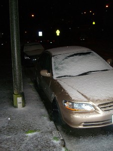
First San Francisco snowfall since 1976
A frigid winter storm is expected to drop the Southland into the deep freeze this weekend.
The National Weather Service has issued a Winter Storm Warning for Southern California beginning Friday through Saturday night.
A cold low pressure system is expected to bring periods of heavy precipitation Friday night through Saturday. Along with gusty winds and very cool temperatures with very low snow levels.
Showers are expected to increase Friday becoming heavy at times late Friday night through Saturday morning as this cold front moves through southwest California.
As a Pacific storm coincided with a blast of cold Canadian air over their fair city, residents here saw snow late Friday, a long-absent visitor for a city accustomed to fog, sweater-weather and other nearly bone-chilling accoutrements.
Predictions had called for the possibility of the first significant snowfall in San Francisco since Feb. 1976, when all of an inch fell, according to the National Weather Service. And just before midnight, several high-lying city neighborhoods, including Twin Peaks, at some 900 feet, reported light snowfall.
The scattering of flakes capped a weeklong flurry of activity among civic leaders and commuters — as well as dreams of flying down some of the city’s famous inclines.
“I can’t wait. It’ll be crazy” – said Marisa Belaski-Farias, 23, a graphic design student from Hawaii who has never seen snow in person. “I have a cardboard box at home. Hopefully there will be enough snow to sled.”
All Friday, it looked like that outing might have to wait. The storm brought soaking rain and howling gales in the early hours, but in classic San Francisco fashion (weather here can vary hour to hour and block to block) the morning rain gave way to clear skies and, in some quarters, profound disappointment.
Snow has fallen in San Francisco, Monterey, and the San Joaquin Valley, and the intensely cold arctic storm was expected to bring snow to the foothills across the Los Angeles area Saturday, the National Weather Service said.
The storm was expected to pass into Southern California around sunrise Saturday, bringing snow to levels as low as 1.500 feet. Snowflakes could fall on the the Santa Monica Mountains, in the Antelope and the Santa Clarita valleys, and in the higher elevations on the northern edge of the San Fernando Valley, such as Porter Ranch, said Curt Kaplan, meteorologist with the National Weather Service in Oxnard.
As for foothill communities like La Crescenta and Altadena, “absolutely, they’ll be getting some snow for sure, at least a dusting of it” – Kaplan said.
In San Francisco, Friday’s sunny skies turned snowy in hilly neighborhoods like Twin Peaks after dark, according to meterologist Mark Strobin of the National Weather Service in Monterey.
“So far, it’s just been a dusting” – Strobin said. Trained spotters for the weather service have reported snowflakes sticking to the wooden fences and beams, but there have not been any reports of snow sticking to the ground in the hills, much less at sea level in the city – Strobin said.
Still, snow has fallen at sea level just outside the weather service’s offices in Monterey. “It’s pretty exciting” – Strobin said, although the snow melted once it hit the ground.
