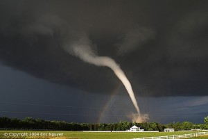
Wichita, Kansas tornado damages
Wichita was under a tornado emergency late Saturday as a large twister, part of a series of severe storms in the Great Plains, moved through south-central Kansas and threatened to destroy homes.
The “confirmed large and extremely dangerous tornado was located just east of Conway Springs and moving northeast at 35 mph” – toward the Wichita area, the National Weather Service reported Saturday night. “This is a particularly dangerous situation.”
Major damage to houses and buildings were likely, “and complete destruction possible” – the weather agency said. But by 10 p.m. (11 p.m. ET), Kansas authorities had reported no serious damages.
Earlier in the day, a possible tornado struck a hospital Saturday evening in Creston, Iowa, according to a dispatcher with the Union County Sheriff’s Department. A search-and-rescue operation was under way.
“We have been hit. We are triaging and moving patients” – a spokeswoman at Greater Regional Medical Center in the south-central Iowa city confirmed.
City Council member Randy White told CNN he was aware of no serious injuries. “A lot of windows have been broken out and some cars have been flipped over. We can’t see a lot right now because the power is out.”
A temporary hospital was set up at Southwestern Community College, White said.
A spate of tornadoes tore through parts of Oklahoma, Kansas, Nebraska and Iowa on Saturday, churning through Wichita and other areas while causing property damage but no immediate reports of deaths or widespread injuries.
Tornadoes skipped across the U.S. Central and Southern Plains and residents braced for the possibility of more, but the twisters primarily affected sparsely populated areas.
A hospital in the town of Creston, Iowa was damaged by a possible tornado, and patients were being moved to hospitals in surrounding communities, according to local officials.
A tornado churned through the city of Wichita, Kansas. Storm chaser Brandon Redmond, a meteorologist with the Severe Weather Alert Team, said the twister passed over his vehicle and lifted it two feet (60 cm) off the ground in an industrial area south of the city.
“The tornado literally formed over our vehicle” – he told Reuters. “I’ve never been that scared in my life. … We had power flashes all around us and debris circulating all around the vehicle, sheet metal, parts of a roof, plywood.”
Damage was reported to a mobile home park, and Redmond said there was significant damage in the industrial area on the city’s south side.
Residents in the affected regions hunkered down for more severe weather. The National Weather Service said the worst conditions were expected in Oklahoma, Nebraska and Kansas, while other areas could see baseball-sized hail and strong winds. Severe storms were also possible from Texas to Minnesota.
“Conditions will remain very favorable through the evening for very strong and potentially long-lived tornadoes” – the National Weather Service said in an advisory. “Tornadoes will be possible in these areas (Nebraska, Kansas and Oklahoma) through the early morning hours.”
Conditions were ideal for a major tornado outbreak in Kansas and Oklahoma Saturday afternoon and evening, weather officials said, and the Wichita area was particularly vulnerable.
Any tornadoes that develop figure to be strong, stay on the ground and move at more than 50 mph.
“The potential for violent tornadoes will be there” – said Chance Hayes, warning coordination meteorologist for the Wichita branch of the National Weather Service Saturday.
The National Oceanic and Atmospheric Administration’s Storm Prediction Center posted a high risk for severe weather in an area roughly bounded by Salina and Topeka in Kansas to the north and Oklahoma City in Oklahoma to the south. Hayes said the bull’s-eye for tornadoes appeared to be bounded by K-14 to the west, K-99 to the east, the Oklahoma border to the south and U.S. 50 to the north.
That would put the Wichita area in the crosshairs.
“We strongly urge everyone in Kansas to be on the alert and determine where you go should a tornado or strong storms bear down on your area” – Maj. Gen. Lee Tafanelli, director of the state emergency management division, said in a statement. “Many events are planned across the state this weekend including sporting events, concerts and proms. Plan now how you will get up-to-date weather information wherever you are, determine where you will take cover, and decide how you will meet up with family if you are not together and phone service is out.”
Saturday’s storms were expected to fire up in the late afternoon or early evening, and strong tornadoes were even possible after sunset.
“The potential for night-time tornadoes is an especially dangerous scenario” – weather service meteorologist Ken Cook said.
Forecasters had been warning of this potential outbreak for several days, urging residents to pay attention to conditions, put together a home survival kit, and be prepared to seek shelter on short notice.
The east-side Target superstore reported being out of gallon jugs of drinking water by early Friday afternoon.
